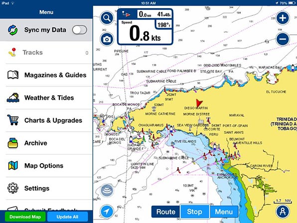
How will they compare?
After hearing multiple positive reviews, I downloaded the iPad version of Navionics yesterday. I look forward to testing it out on our return trip to Grenada, and comparing it to the Garmin Bluechart Mobile app that we have been using up to this point.


I too am curious…
I’ll report back.
Biggest reason it is better is that it includes boat speed. Garmin blue chart does not in interest of supporting its full blown marine systems. BUT blue chart has active captain.
Be careful as you add regions in Navionics to do it in the same app. They used to require separate apps for each region and I can not combine as a legacy customer. Annoying.
The track feature is cool on navionics. Downloading much more annoying on navionics vs blue chart. Don’t care about navionics depth sounding cloud based mumbo jumbo.
I bet it would look nice on a new iPad Pro. 🙂
I have both. I like them both for different reasons. The Garmin I like because it’s got Active Captian imbedded and I like the navionics because for the most part it has better chart detail.
Active Captain is excellent.
When I was in the Western Caribbean, the lack of detail to be found in the Active Captain Interactive Crusing Guidebook was noticeably less than in the Eastern Caribbean. This may be due to less people cruising there, less Internet, or both. As we moved West and then through the Panama Canal, the Internet became so incredibly slow that using Active Captain was a real chore, so it wasn’t used. When I got to Tahiti and had decent Internet, I back tracked across our path and was surprised to see no markers in the popular and heavily visited places where we had been. I like Active Captain, but don’t miss it. On the other hand, I wonder if the charts are actually the same with Garmin Blue Chart and Navionics?
While it’s possible they are based on the same charts, I don’t know, their representation of the data is definitely different.
It’s a shame that you can’t get radar and ais onto the ipad else there’d be no use for the old clunkers that are chart plotters right.
I believe you now can using some sort of wireless hardware interface.
I have used navionics on my iPad as a backup to my garmin chartplotter for a couple of years.
For fishing the garmin was better , but when navigating I found I tended to look at the navionics more, it is very easy to read, but it won’t talk to my autopilot.
I recently downloaded the garmin maps for my ipad after reading your mention of it.
It is nowhere near as good as the chartplotter version of the garmin charts and I also find navionics superior in most respects.
I agree. The Garmin charts on their plotters are far superior.
In my Navionocs version it’s included:”not for navegational use”!
Real Marine chart plotters make you agree to something equally as stupid when they start up. Lawyers!
Have you looked at OpenCPN?
Laptop, yes. Tablet, no.